
Track My Location: A Practical Safety Guide for 2026
A 10 p.m. rideshare pickup ends in an unfamiliar suburb. Your friend isn’t asking for a polished map view or a permanent location history. They’re asking one practical question: where are you right now? The same question matters when a student leaves a night class, a delivery driver takes a rural route, or a lone worker misses an expected check-in.
Live location tracking can answer that question, but only when it has been set up for the situation. A blue dot isn’t proof that someone can reach you, identify the right entrance, or understand what has gone wrong. Location can be stale, imprecise, unavailable indoors, or visible to more people than you intended.
This guide treats visibility as a controlled safety tool, not a default setting. You’ll learn when to switch sharing on, who should receive the signal, how long access should last, and what to do when your phone or tracking app misbehaves.
Table of Contents
- Why Live Location Tracking Matters Right Now
- Setting Up Location Permissions the Right Way
- Sharing Your Location With Trusted Contacts
- What Your Phone GPS Can and Cannot Do
- Privacy Rules for Safer Location Sharing
- Fixing Common Live Tracking Problems
- Your Pre-Departure Tracking Checklist
Why Live Location Tracking Matters Right Now
Live location tracking is a time-bound, opt-in broadcast of your current position to selected people or services. It isn’t the same as passive location history, which records places you visited without necessarily giving a trusted contact a live view or a way to respond.
That distinction matters during a late walk. A friend watching a live route can see movement, a pause, or a route change. A location-history record may only help after the fact. The live workflow has value because another person can notice context and act while the situation is unfolding.
Three decisions control whether tracking helps
First, decide when sharing should begin. Use it for a defined risk window, such as walking from a station, taking a rideshare, entering a night shift, or travelling through an unfamiliar area. Don’t leave it running just because it was useful once.
Second, choose who receives the signal. A small group of trusted contacts is easier to monitor than a broad family account or a large social audience. Each viewer should understand what the location means, how to contact you, and what to do if updates stop.
Third, prepare for failure. A missing update may mean poor satellite reception, weak cellular service, a sleeping app, a depleted battery, or an intentional privacy pause. The person watching needs a last-known location, a route or destination, and a way to contact you.
Practical rule: A live pin is useful only when someone knows how fresh it is and what action to take if it stops moving.
Emergency location systems show why precision can’t be assumed. The FCC’s historical E911 framework distinguished handset-based and network-based accuracy, with different requirements for each technology, rather than treating every mobile position as equally reliable in its archived Phase II framework. Your goal isn’t to create a perfect responder-grade position on a consumer phone. It’s to give a trusted person timely context, then use communication and emergency services when the situation demands it.
Setting Up Location Permissions the Right Way
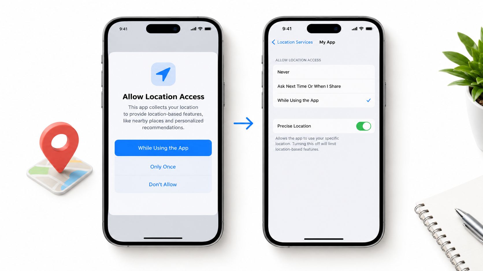
Start with the permissions for the specific tracking app, then verify the phone-wide settings that control background activity. On an iPhone, the first meaningful choice is usually While Using the App. That lets the app obtain location while you’re actively viewing or using it, but it may not support reliable updates after the screen locks.
Choose Precise Location when you need a dependable check-in or route view. Approximate location can be appropriate for ordinary privacy, but it weakens the usefulness of a late-walk map when a contact needs to distinguish a building entrance, side street, or nearby path.
Background access changes the workflow
If the app asks for Always Allow, accept it only when you understand why background updates are necessary. iOS may display a warning that names the app and reminds you that it can use location in the background. That warning is useful. Read it, then decide whether the safety session justifies the access.
Choosing Once or Never limits the app’s ability to maintain a live route after the prompt expires or the app closes. You may still see a position while the app is open, but the viewer can end up looking at a stale pin after the phone sleeps. A background geofence or movement alert may also fail.
Check the following settings before relying on a live session:
- Location Services: Keep it enabled for the phone and the tracking app.
- Precise Location: Enable it for route-level sharing and accurate check-ins.
- Motion & Fitness: Allow access when the app uses movement to adapt prompts or recognize travel.
- Local Network: Permit it if the app uses nearby Wi-Fi information to improve indoor positioning.
- Background App Refresh: Enable it so the app can maintain necessary background activity, subject to the phone’s power and system policies.
- Low Power settings: Review them before a long trip because aggressive power saving can delay updates.
On Android, the labels differ by manufacturer, but the principle is the same. Check location permission, background usage, battery optimization, nearby-device or Wi-Fi access where requested, and notification permissions.
Verify before you leave
Open the app with the phone active and confirm that the correct map view shows a fresh blue dot. Ask a trusted viewer to confirm that they can see the update, not merely that they can open the map. If the timestamp is old, fix the permission or background setting before starting the journey.
Sharing Your Location With Trusted Contacts
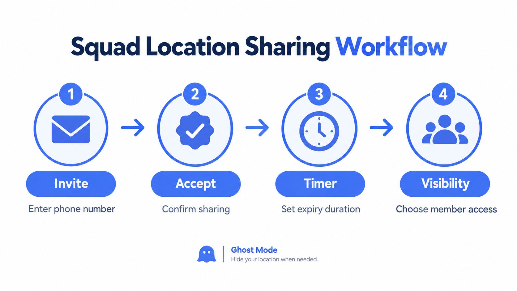
Treat a viewing group as a named, deliberate group, not a broadcast list. Invite a person using their phone number, wait for them to accept the share, then set an expiry time that matches the activity. Give each member only the visibility they need. A person who checks that you arrived may not need access to every route or future session.
A practical sharing flow looks like this:
- Invite: Enter the trusted contact’s phone number and send the invitation.
- Accept: Have the contact confirm the share before you start moving.
- Set a timer: Choose an expiry that ends after the walk, ride, or shift.
- Choose visibility: Decide which members can see the live map, route, media, or status.
The live location sharing workflow should make those choices visible rather than burying them in a general account setting.
Use privacy controls deliberately
Ghost Mode temporarily takes your pin off the map while allowing the service to show that you’re online. Use it when you arrive at a sensitive medical or legal appointment, enter a private address, or need a short privacy pause. Don’t use it to conceal an active emergency from the person responsible for monitoring you.
A nudge is different from a full hide. It lets a viewer send a short prompt such as a welfare check without requiring you to type while walking. You can reply with a one-tap status when your hands or attention are occupied.
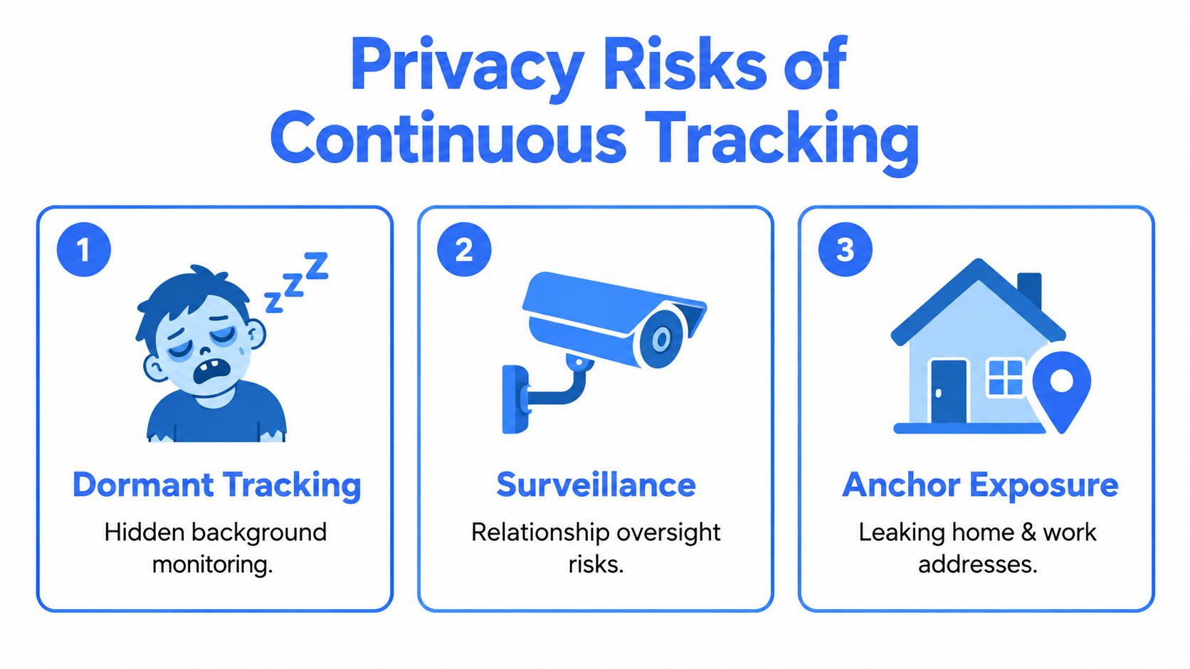
Entry pins can help viewers or responders identify a relevant entrance, but they also expose sensitive anchors. Use them for a planned safety workflow, not for every occasional contact. Don’t attach home, work, or gym details to a broad group unless everyone with access needs them.
For a Saturday night outing, create a small Squad before leaving, set sharing to cover the journey and expected return, and leave Ghost Mode off while travelling. At the venue, use Ghost Mode if you don’t want the group to see the exact entrance or address. When you start the ride home, turn Ghost Mode off, check that the live dot refreshes, and end the share once you’re safely inside.
What Your Phone GPS Can and Cannot Do
A phone’s location is a sensor-fusion estimate, not a guaranteed point. The operating system may combine GNSS, Wi-Fi positioning, cellular information, motion data, and previous fixes. Performance changes with the building, street layout, signal obstruction, device, carrier, and availability of mapped Wi-Fi access points.
The FCC’s emergency-location benchmarks illustrate the difference between consumer awareness and dispatch-grade requirements. Its current framework requires nationwide wireless providers to provide dispatchable location or horizontal location within 50 meters for 80% of wireless 911 calls, while applicable vertical location must support accuracy within plus or minus 3 meters for 80% of calls under the FCC’s indoor location benchmarks. Dispatchable location may include a civic address and, where feasible, a floor, room, office, or apartment number.
Signal source changes the result
| Environment | GPS alone | Assisted GPS and Wi-Fi | Cell positioning only |
|---|---|---|---|
| Open outdoor area | Often useful for route awareness | Can improve time to a usable fix | Usually broader and less precise |
| Dense urban street | Buildings can obstruct or reflect signals | Wi-Fi and network data may improve the estimate | May identify a wider area than the actual street position |
| Indoor environment | May degrade or disappear | Results depend on nearby mapped access points | Often provides coarse context |
| Underground or obstructed area | May be unavailable | Can help only where supporting signals exist | May preserve a broad last-known area |
NIST testing found that Wi-Fi availability was a key condition for indoor accuracy gains, and that Android Fused Location Provider and Apple Core Location could meet the FCC’s 50-meter benchmark in tested environments, with meaningful variation by building and platform in its smartphone location testing. That finding supports a simple operating rule: don’t judge location performance in one room and assume it will behave the same way in a parking garage, high-rise, or rural road.
A shared pin also isn’t the same as emergency dispatch access. A friend may see a moving route while a 911 center receives different information through the carrier and local systems. If you call for help, state the last known position, nearby landmarks, building name, floor, entrance, and direction of travel. A phone location app can complement that information, but it can’t replace direct communication with emergency services.
For professional properties, campuses, or lone-worker operations, it can also help to review how remote security systems combine monitoring and response procedures. Test your own location by comparing the dot with a known landmark outdoors, near a dense building, and indoors. Record whether the dot is fresh, whether it jumps, and whether the viewer can tell when the fix becomes uncertain. Use practical steps to improve location accuracy before treating the workflow as ready.
Privacy Rules for Safer Location Sharing
Continuous sharing creates a second safety problem: uncontrolled visibility. A dormant tracking session can reveal routines, home and work anchors, relationships, and visits that the recipient never needed to see. That risk is especially serious for people dealing with stalking, domestic abuse, or coercive control.
A 2025 U.S. government oversight report warned that GPS services, physical tracking tags, rideshare apps, and default-public privacy settings can expose a victim’s identity or location to an abuser. It also noted that third-party data sharing may be enabled without explicit consent in its review of technology-enabled abuse.
Use bounded visibility
Set a sharing window around a defined activity. A walk, ride, shift, or appointment has a beginning and an end. When the activity ends, revoke access the same day and disable the group view while you’re stationary.
Apply these rules consistently:
- Keep the group small: Invite people who can recognize a problem and act, not everyone who asks.
- Set an expiry: Match access to the journey rather than leaving it open-ended.
- Review history: Check which contacts can see routes, recordings, or previous locations.
- Protect anchors: Avoid exposing home, work, school, or regular gym entrances to occasional contacts.
- Separate audiences: A trusted friend, employer, platform, carrier, and emergency service don’t need the same access.
- Plan a privacy pause: Know how to stop routine sharing without disabling the emergency path you may need.
Ghost Mode is useful when you need to disappear from the map temporarily, but you should understand what it communicates. It can stop ordinary location broadcasting while leaving an online status visible. A nudge can ask whether you’re safe without revealing your full route, so it shouldn’t be treated as equivalent to hiding all activity.
Ghost Mode controls are most valuable when they’re easy to activate and easy to reverse. Use them before entering a sensitive location, not after an unwanted viewer has already learned the address.
A safe default is simple: share the minimum location data for the shortest useful time with the fewest appropriate people. Visibility should be something you pick up for a journey and put down when the journey ends.
Fixing Common Live Tracking Problems
Most live tracking failures fall into four categories. Treat each as a diagnostic problem, not as proof that the person is safe or unsafe.
The pin is stale
Background location can be limited when iOS or Android puts an app to sleep, restricts background activity, or applies battery optimization. The viewer may see a convincing map dot that represents the last successful fix.
Fix: Allow the tracking app to use location in the background, permit background refresh where available, and remove restrictive battery optimization for an active safety workflow.
Verify: Lock the phone, move a short distance, and ask the viewer whether the timestamp and position update. If they don’t, don’t start the journey yet.
The signal drops
Airplane mode, weak cellular coverage, blocked satellite signals, or a network transition can interrupt updates. A VPN or other network configuration may also interfere with the app’s ability to communicate, although the exact effect depends on the device and service.
Fix: Turn off Airplane Mode, confirm that cellular data is available, and test the app without a network configuration that blocks its traffic.
Verify: Refresh the viewer’s map after moving into an open area. If the service supports a cellular fallback, confirm that it reports a new fix instead of holding the previous one.
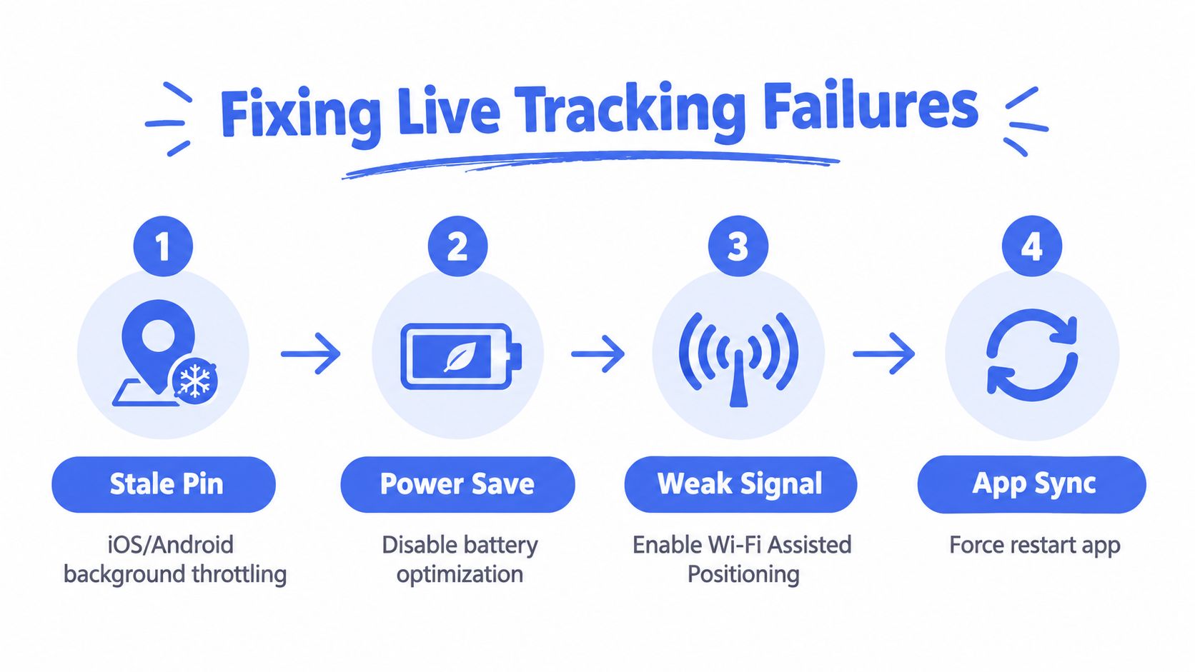
Indoor positioning fails
In a basement, underground station, or heavily obstructed building, GNSS may disappear. Wi-Fi positioning can help only when the phone can identify nearby mapped access points. The map may hold the last valid point, show a broad estimate, or report that location is unavailable.
Fix: Use a manual check-in with a clear landmark, floor, room, or entrance. Send the last known position and a short written description rather than trusting a precise-looking stale dot.
Verify: Have the viewer acknowledge the check-in and repeat the location details back to you.
The battery falls too quickly
Continuous location, screen use, video, weak signal, and background activity can all increase power consumption. Don’t promise an exact battery cost because it varies by phone, signal, app, and settings.
Fix: Start with a charged phone, reduce unnecessary screen use, carry a power bank, and use the service’s lower-power tracking mode when continuous high-detail updates aren’t necessary.
Verify: Check the battery level before departure and after a short test session. If the phone can’t support the planned journey, change the monitoring plan before leaving.
Your Pre-Departure Tracking Checklist
You don’t need a complicated safety routine. You need a repeatable check that fits between picking up your keys and opening the door.
The 60-second check
- Open the tracking app: Keep it in the foreground while you start the session.
- Select the correct Squad: Confirm that the intended trusted contacts are viewing, not an old group.
- Check the share window: Make sure the expiry covers the journey, shift, or ride.
- Confirm Ghost Mode status: Turn it off when active sharing is intended.
- Check Precise Location: Verify that the phone can provide a route-level fix.
- Confirm background refresh: Make sure the app can continue after the screen locks.
- Look for the location indicator: A fresh location arrow or equivalent status signal should appear.
- Ask for confirmation: Have one viewer confirm that the dot is current and the timestamp is updating.
Match the routine to the risk
For a late walk, use a short sharing window, a small Squad, and a clear destination. Include an entrance or landmark only when the viewer needs it.
For a rideshare, start sharing before pickup, check that movement follows the expected route, and keep a way to contact the driver or emergency services outside the map view.
For lone work, define the shift window, agree on a missed-check-in response, and provide the building, floor, or access details that a map coordinate can’t express.
If the dot freezes, don’t reassure yourself because it looks precise. Check the timestamp, try a manual check-in, contact the person, and use direct emergency communication when the situation warrants it. The safest workflow combines location with a human watcher, context, and a clear escalation plan.
3rd-i offers live location sharing alongside live video and audio for selected contacts and trained Safety Agents, with tools such as Squad viewing, SOS workflows, Ghost Mode, and emergency dispatch coordination through RapidSOS. If you want to test a controlled location workflow for late walks, rideshares, or lone-working situations, visit 3rd-i and review how its monitoring and privacy controls fit your safety plan.